*Holly found this post of Brendan’s from last June(!!!) lingering in the drafts awaiting her approval. She apologizes for the long delay in posting it!
One of our collections here in Georgia College’s Special Collections is the various maps that have been collected over time. This collection is open to for use but rarely sees much interest from researchers. Maps are a great source of information for all studies. In this collection, there are maps for agricultural studies, transportation studies, Civil War battle studies, and even studies about Milledgeville dating back to the very beginning of the city. Maps put a visual image behind the words that relay in the story and can tell a lot about the subject.
Over the summer, I took it upon myself to update the finding aid for the maps collection.This collection peaked my interest not only because I have a degree in geography, but also because of the stories some of these maps tell. To my chagrin, this also meant reprocessing a collection that had seen some of its items relocated or replaced in the wrong order. That meant that I needed to review each map to ensure that it was back to its correct home in the collection. What I thought was going to be a chore turned into many rabbit holes as I found myself studying each map.
For example, the map below shows the 13 original states in 1784 just after the American Revolution and independence from Great Britain. Many of the states claimed much more territory than what they have today. The states in the South claimed land all the way to the Mississippi River, as did Connecticut.
 This map shows the original layout of the United States and the beginning of territorial issues that lead to the formation of states such as Tennessee, Kentucky, and Alabama. This territory was the foundation for the country and the future idea of Manifest Destiny. The story of the beginning of the United States is brought to life in this particular map. Continue reading “Maps, Maps, Maps!”
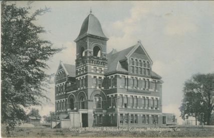 nymore, but here you are.) And if you’ve ever wondered why historians rely so heavily on prospectuses from 1891 to 1924, here’s your answer: the main building of the G.N. & I.C. campus burned in 1924, sending all administrative records up in smoke. What have we got to go on, then? Prospectuses, photographs, and personal histories recorded in memorabilia.